Cabot Trail

We were up early today and on our way by 7:00. We were well on our way to North Sydney when Gail remembered that we had not refuelled. Recalling a previous trip around the Cabot Trail one memory was the limited opportunities to refuel. We left the highway at the first fuel sign sort of expecting it would be close to the exit. Not so! We ended up in North Sydney before finding a gas station. It was a nice drive and we were in no hurry. Fuel tank full, we again set out for the Cabot Trail entry point at South Haven.

The road is a very twisty turny upsi downsi affair. A total of about 200 km (125 miles) with the highest elevation being about 450 metres (1475 feet). While every twist and turn reveals new vistas photos soon begin to seem repetitive so I have tried to restrain myself and offer a sample of about 20 in the Photo Gallery.

During the tour we were without cell service for about 30% of the time, mainly the northern and western sections and XM radio reception was also spotty but GPS was always present. There were emergency telephones located periodically but it was a reminder that reliable mobile telephone service is not guaranteed. Restrooms were another item in short supply.

We ended today’s trip at a quaint hotel in Antigonish, Nova Scotia, that had a restaurant on site. Another opportunity for me to enjoy Atlantic seafood, salmon tonight. It was a great day overall and the weather was nearly perfect.

The highways in this part of Canada are strange to Ontario folk like me. They vary in colour from black to red to green. They also have a strong tendency to pull the steering toward the right. Occasionally, there is a rapid slewing right to left. On the positive side, there are few potholes.

Check out the photos. Tomorrow will be a short drive but it will be our 58th anniversary.


Terry Pratchett, The Light Fantastic

You haven’t really been anywhere until you’ve got back home.

Cape Breton Island

There was no rush to get on the road today, only 300 km to Sydney. It was a cool, bright morning and after a refuelling stop, we were on our way. There is only one route to Cape Breton Island, Highway 104. The Canso Causeway is the only link between the Nova Scotia mainland and Cape Breton Island. The island accounts of nearly 20% of the total area of Nova Scotia and about 15% of its population. It contains an inland sea called Bras d’Or Lake which is open to the ocean but is also fed from fresh water rivers. The Cabot Trail is a major attraction where it is possible to spend days visiting attractions, hiking and eating. We are just going to drive from South Haven to Margaree Harbour which is not the entire 298 km and only a quick look.

I had expected to find more side trips on today’s trip but St Peter was really the only one. We drove along the shore of Bras d’Or Lake which is very pretty and varied but photos don’t show it well. When we arrived in Sydney we stopped to replenish our lunch supplies then continued to our hotel, an hour early. The desk clerk was very pleasant and accommodating so we were checked in early.

When we arrived, we inquired about a place for dinner and were referred to Governors Pub. We took a drive to local the pub and found hoards of tourists from the three cruise ships in port. The Celebrity Eclipse, Norwegian Sky and Emerald Princess were in port which probably unleashed 5,000 or more tourists on Sydney. We did see the ships from our hotel in the south of the city.

We returned to Governors Pub for dinner after the ships had departed. When we arrived at the pub it was nearly deserted. The locals gradually arrived as we ate our meal. Yes, I did get my first lobster dinner in years.


Terry Pratchett, A Hat Full of Sky

Why do you go away? So that you can come back. So that you can see the place you came from with new eyes and extra colors. And the people there see you differently, too. Coming back to where you started is not the same as never leaving

Edmunston to Truro

After a reasonably good night’s sleep we started for Truro, Nova Scotia. It was the coolest morning so far at about 5 degrees celsius and there was some fog as we started our highway drive eastward. It was not too heavy and it became patchy but it presented an eerie glow as we drove into the sun. And then it was gone. The sky was generally overcast with sunny breaks throughout the day.

It was pretty much a scenic drive through the hilly countryside. The trees have not yet begun to show much of their autumn colours but there is just a hit that the change is not far away. This was the shortest leg of the trip so far and we arrived in Truro at 3 PM Atlantic Time.

After we were checked into the motel we decided to take a little side trip so we started toward Portapique along the north side of Cobequid Bay which is an extension of the Bay of Fundy. It was nearly high tide so the marshes were very wet. We will not get to see it at low tide this time but we will see the bay of Fundy twice as we are in port at St John, New Brunswick and possibly a full tidal cycle.

Our side trip took us along a one and a half lane gravel road Along the shore of Cobequid Bay. We saw numerous homes, some of which looked like all season homes while others suggested cottage life.

So now, after dinner, we are relaxing in preparation for a very short day tomorrow. This may allow for some scenic side trips or detours. Check out today’ pictures in the “East Coast Road Trip 2024 · Maritime Cruise 2024” item in the Photo Gallery menu.


Rick Steves

Travel is rich with learning opportunities, and the ultimate souvenir is a broader perspective.

Edmunston, first stop in the Maritimes

We started the day too early. Somehow the first day of travel is more tiring than it should be so we fell asleep too early and Gail was awake before 5 AM which meant I would be awakened not long after. That made it easy to get to the 6:30 breakfast. After a refuelling stop we were on Highway 20 by 7:15. Highway 20 does not have the same kind of service centres as on Ontario 401 but the services were regular and well advertised. Today we shared the driving whereas yesterday I did it all.

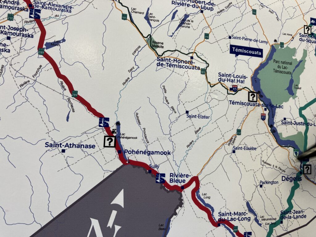
After we passed Montreal traffic eased and once passed Quebec City, or Levis, the scenery became more interesting. There were farms and forests and eventually we could see mountainous terrain across the St Lawrence which was occasionally in sight. Gail took her second shift in the driver’s seat as we approached Rivière-du-Loup and I navigated the transfer to Quebec highway 85. Almost as soon as we started south on 85 things became strange and we found ourselves navigating country roads which seemed to take us further from Highway 85. I had some awareness of a construction project on 85 but was unable to find any information about detours before we left home. While Gail drove I began consulting both Apple maps and Google maps only to discover that their detour routes were not identical. When we finally reached Highway 85 again both Apple and Google located us in the middle of nowhere since the newly constructed highway was not up to date for either system. My solution was simple, follow that truck. That seemed to work. At our last rest stop before Edmunston we found a Quebec Information Centre where the attendant was only too pleased to show me how to avoid all the construction. The secret, he said, was to aim for Pohénégamook, Quebec then take Highway 289 north to Highway 20. We shall try that on our return trip.

I’m adding a few more photos today which can be viewed in the sidebar or in the East Coast and Maritime Cruise 2024 Photo Gallery. We will undoubtedly find a few more photo opportunities in days to come.


Susan Sontag

I haven’t been everywhere, but it’s on my list.